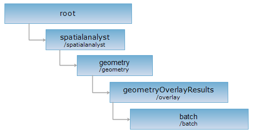
<geometryOverlayResult_uri>/batch[.<format>]
批量空间对象叠加分析结果集资源。对batch资源执行POST请求,可以创建一个批量对象叠加分析结果。
支持的方法:
支持的表述格式:RJSON、JSON、HTML、XML。

对如下 URI 执行 HTTP 请求,以 rjson 输出格式为例加以说明,其中,supermapiserver 是服务器名。
http://supermapiserver:8090/iserver/services/spatialAnalysis-spatialAnalyst/restjsr/spatialanalyst/geometry/overlay/batch.rjson
URI参数如下:
| 名称 | 类型 | 含义 |
| ignoreAnalystParam | boolean | 设置返回的结果中是否忽略参与分析的源几何对象和操作几何对象。为避免返回结果描述过多,可设置 ignoreAnalystParam为 true,即不显示参与分析的源几何对象和操作几何对象。 |
| returnContent | boolean | 是否立即返回新创建资源的表述还是返回新资源的 URI。如果为 true,则直接返回新创建资源,即分析结果的表述。为 false,则返回的是分析结果资源的 URI。默认为 false。 |
请求体参数如下:
| 字段 | 类型 | 说明 |
sourceGeometry |
Geometry[] |
源几何对象数据,即被操作几何对象,其数据类型与 operation 操作类型有关。 其中, clip、erase、intersect、identity 操作的被操作几何对象的数据类型为点、线、面状几何对象;union、update、XOR 操作的被操作几何对象的数据类型为面状几何对象。 |
| operateGeometry | Geometry[] | 操作几何对象数据,数据类型为面状几何对象数据。 |
| tolerance | double | 节点容限。在叠加分析节点捕捉的过程中,节点容限设定了节点捕捉的容忍程度。当数据中两点的距离小于节点容限时,会被认为是重合的节点;而距离大于节点容限的点则保留不变。默认值为 0.0000000001。 |
| operation | String | 叠加操作,可选值为 clip(裁剪)、erase(擦除)、identity(同一)、intersect(相交)、union(合并)、update(更新)、XOR(对称差)。 |
当 returnContent为false时,返回的是分析结果资源的 URI,响应结果中参数:
| 字段 | 类型 | 说明 |
succeed |
boolean | 查询是否成功。 |
| newResourceID | String | 分析结果资源的 ID。 |
| postResultType | PostResultType | POST 请求的结果类型,枚举说明 POST 请求对目标资源的影响,即处理结果是什么样的。 |
| newResourceLocation | String | 创建的新资源的 URI。 |
当 returnContent 为 true 时,则返回结果资源的表述集合,其中单个描述集包含:
| 字段 | 类型 | 说明 |
| succeed | boolean | 叠加分析是否成功;成功则返回 true,否则返回 false。 |
| image | ImageResult | 空间分析结果图片。表达了 SuperMap iServer 空间分析结果产生的图片以及图片信息相关的描述。 |
| message | String | 叠加分析过程中产生的相关信息。 |
| resultGeometry | Geometry | 空间分析结果几何对象。 |
| operateGeometry | Geometry[] | 操作几何对象数据。当在URI中设置 ignoreAnalystParam为false或不设置 ignoreAnalystParam参数时,operateGeometry有值,反之为空。 |
| sourceGeometry | Geometry[] | 源几何对象数据。当在URI中设置 ignoreAnalystParam为false或不设置 ignoreAnalystParam参数时,sourceGeometry有值,反之为空。 |
对 batch 资源执行 POST 请求。URI为:http://supermapiserver:8090/iserver/services/spatialAnalysis-spatialAnalyst/restjsr/spatialanalyst/geometry/overlay/batch.rjson?returnContent=true&ignoreAnalystParam=true,请求体如下:
{"sourceGeometries":[{"type":"REGION", "points":[{"x":23, "y":23}, {"x":33, "y":35}, {"x":43, "y":22}]},{"type":"REGION", "points":[{"x":25, "y":25}, {"x":37, "y":39}, {"x":45, "y":24}]}], "operateGeometries":[{"type":"REGION", "points":[{"x":23, "y":23}, {"x":34, "y":47}, {"x":50, "y":12}]},{"type":"REGION", "points":[{"x":25, "y":28}, {"x":38, "y":45}, {"x":54, "y":15}]}], "operation":"INTERSECT"}
返回的结果如下:
[
{
"operateGeometry": null,
"result": {
"image": null,
"message": null,
"resultGeometry": {
"center": {
"x": 38.3380604288499,
"y": 31.512426900584796
},
"id": 1,
"partTopo": [
1,
1
],
"parts": [
4,
6
],
"points": [
{
"x": 41.6,
"y": 30.375
},
{
"x": 44.50292397660819,
"y": 24.02485380116959
},
{
"x": 45,
"y": 24
},
{
"x": 41.6,
"y": 30.375
},
{
"x": 33.270270270270274,
"y": 34.648648648648646
},
{
"x": 37,
"y": 39
},
{
"x": 41.6,
"y": 30.375
},
{
"x": 44.50292397660819,
"y": 24.02485380116959
},
{
"x": 41.32,
"y": 24.184
},
{
"x": 33.270270270270274,
"y": 34.648648648648646
}
],
"prjCoordSys": null,
"style": null,
"type": "REGION"
},
"succeed": true
},
"sourceGeometry": null
},
{
"operateGeometry": null,
"result": {
"image": null,
"message": null,
"resultGeometry": {
"center": {
"x": 33.11356614915334,
"y": 31.083629893238435
},
"id": 2,
"partTopo": [
1,
1,
1
],
"parts": [
5,
5,
5
],
"points": [
{
"x": 26.8576512455516,
"y": 27.16725978647687
},
{
"x": 33.270270270270274,
"y": 34.648648648648646
},
{
"x": 41.32,
"y": 24.184
},
{
"x": 32.532467532467535,
"y": 24.623376623376622
},
{
"x": 26.8576512455516,
"y": 27.16725978647687
},
{
"x": 37.8051948051948,
"y": 22.25974025974026
},
{
"x": 32.532467532467535,
"y": 24.623376623376622
},
{
"x": 41.32,
"y": 24.184
},
{
"x": 43,
"y": 22
},
{
"x": 37.8051948051948,
"y": 22.25974025974026
},
{
"x": 26.577405857740587,
"y": 27.292887029288703
},
{
"x": 33,
"y": 35
},
{
"x": 33.270270270270274,
"y": 34.648648648648646
},
{
"x": 26.8576512455516,
"y": 27.16725978647687
},
{
"x": 26.577405857740587,
"y": 27.292887029288703
}
],
"prjCoordSys": null,
"style": null,
"type": "REGION"
},
"succeed": true
},
"sourceGeometry": null
},
{
"operateGeometry": null,
"result": {
"image": null,
"message": null,
"resultGeometry": {
"center": {
"x": 26.97699424006954,
"y": 24.77631364451448
},
"id": 3,
"partTopo": [
1,
1
],
"parts": [
4,
7
],
"points": [
{
"x": 25,
"y": 25
},
{
"x": 26.8576512455516,
"y": 27.16725978647687
},
{
"x": 32.532467532467535,
"y": 24.623376623376622
},
{
"x": 25,
"y": 25
},
{
"x": 23,
"y": 23
},
{
"x": 26.577405857740587,
"y": 27.292887029288703
},
{
"x": 26.8576512455516,
"y": 27.16725978647687
},
{
"x": 25,
"y": 25
},
{
"x": 32.532467532467535,
"y": 24.623376623376622
},
{
"x": 37.8051948051948,
"y": 22.25974025974026
},
{
"x": 23,
"y": 23
}
],
"prjCoordSys": null,
"style": null,
"type": "REGION"
},
"succeed": true
},
"sourceGeometry": null
}
]
返回跟 GET 请求一样的 HTTP 响应头,但是没有响应实体。可以在不必传输整个响应内容的情况下,获取包含在响应消息头中的元数据信息。元数据信息包括媒体类型,字符编码,压缩编码,实体内容长度等。
HEAD 请求可以用来判断 batch 资源是否存在,或者客户端是否有权限访问 batch 资源。通过对加.<format>的 URI 执行 HEAD 请求,还可以快速判断 batch 资源是否支持<format>格式的表述。